Mound Park and the Preservation of the Portsmouth Earthworks
Text
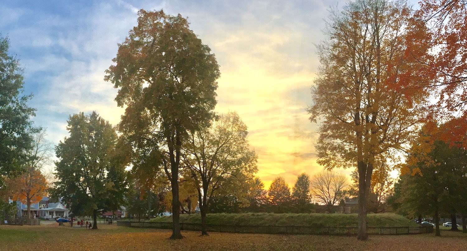
Portsmouth's Mound Park lays claim to the lone remnant of the central complex of the Portsmouth Earthworks that once spread across the Ohio River over the modern communities of Portsmouth, Ohio and South Portsmouth and South Shore, Kentucky. The history of Mound Park spans over 2000 years of human activity at the mouth of the Scioto River.
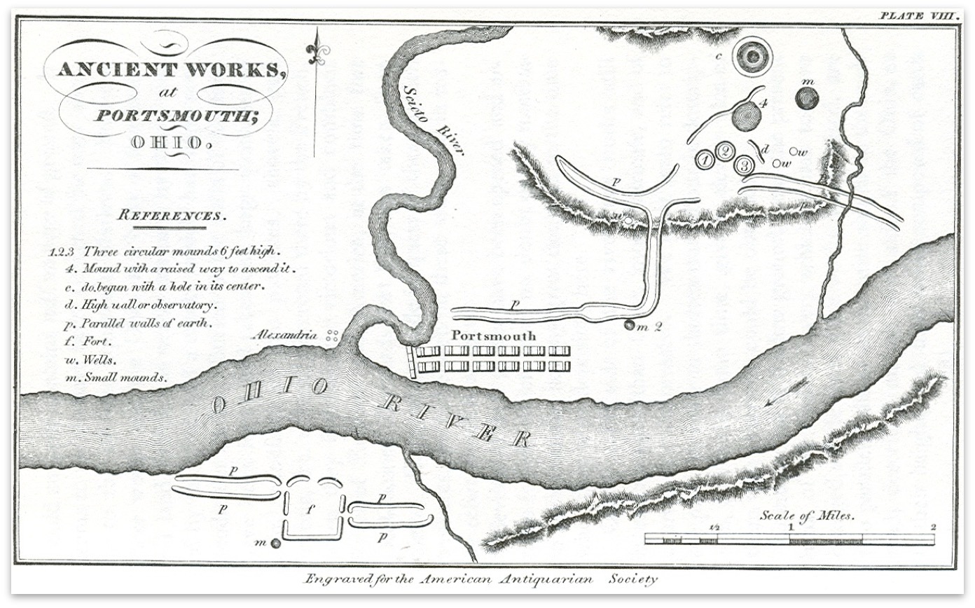
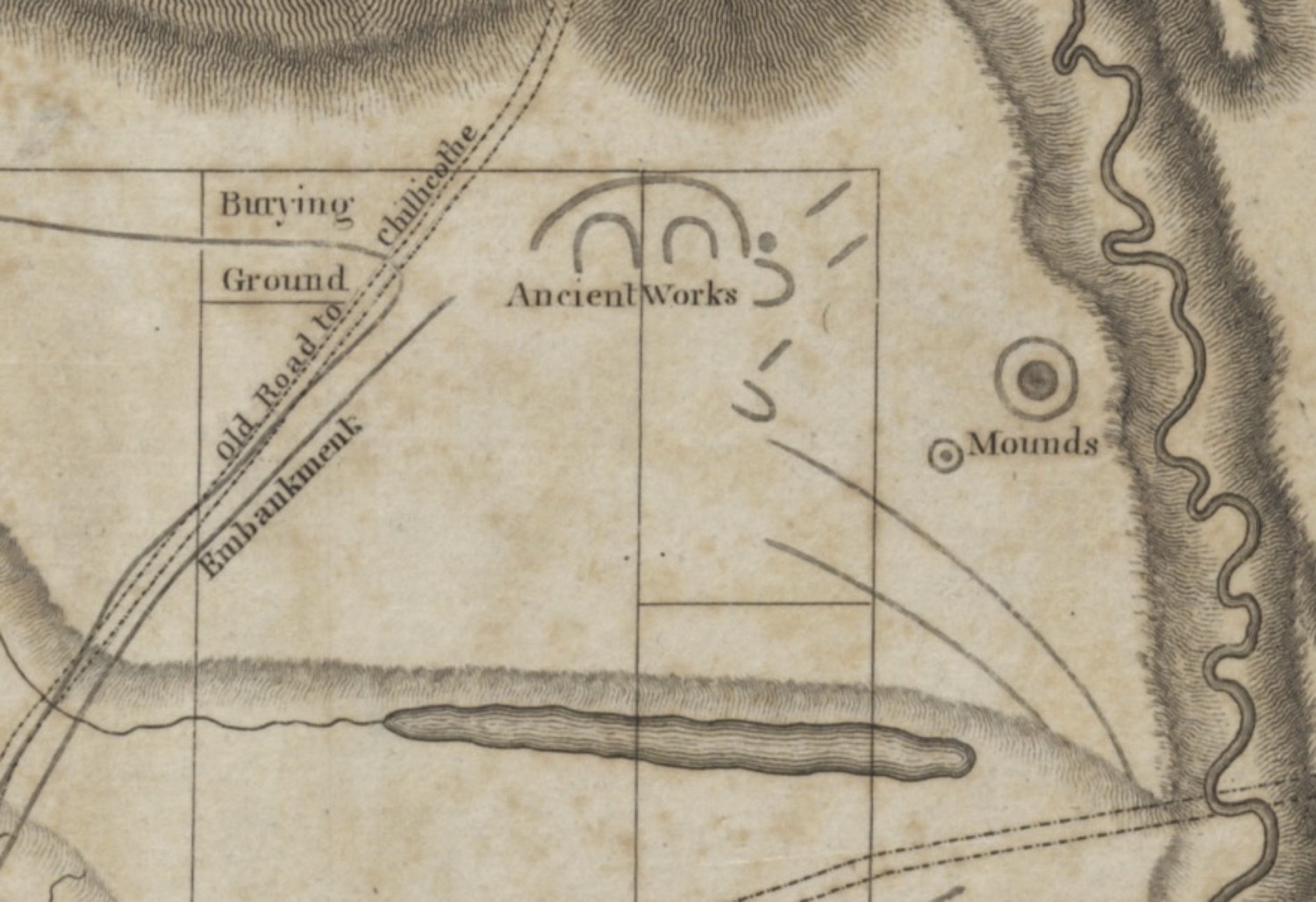
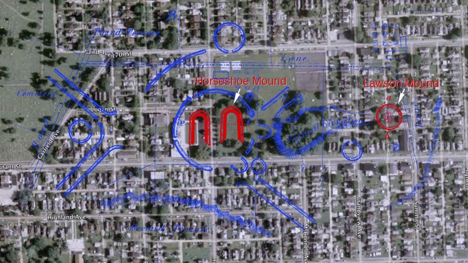
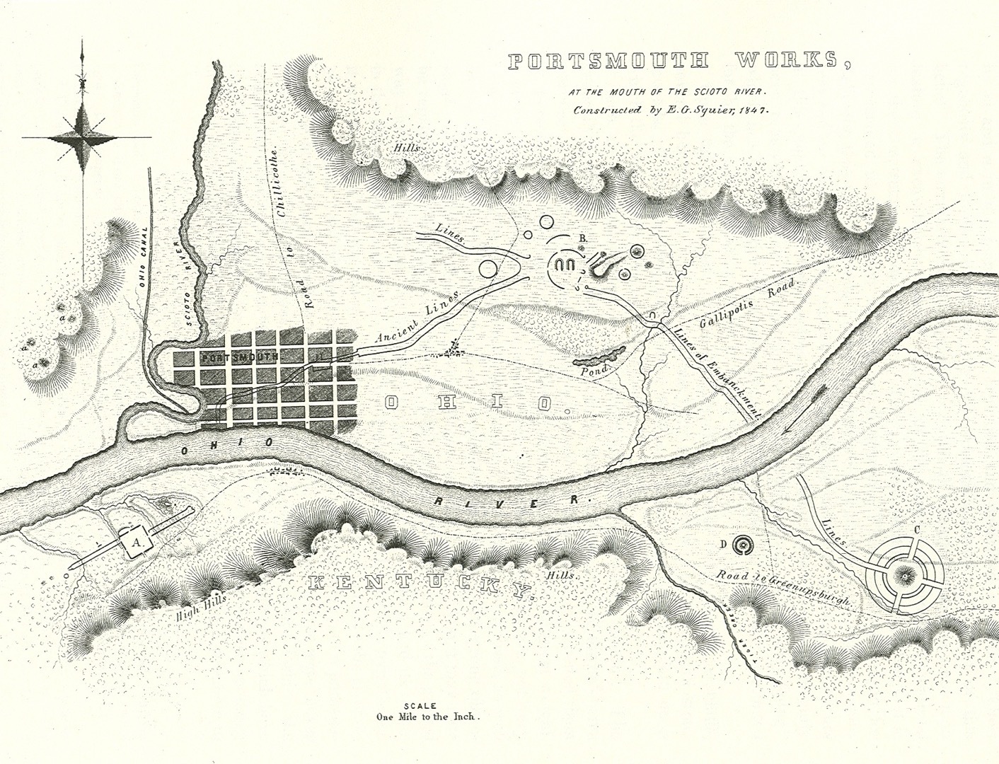
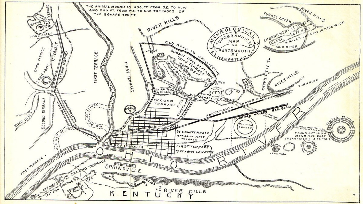
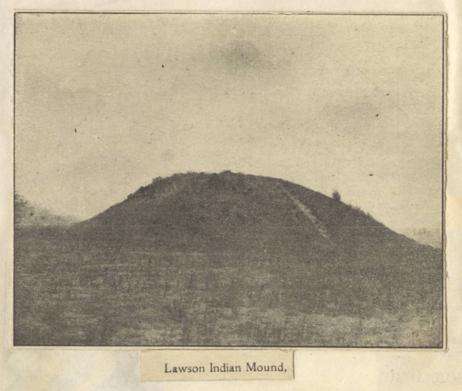
All that survives today is a horseshoe-shaped mound, which was one of a pair that were the focal point of the earthworks complex. Caleb Atwater produced the first known sketch map of the earthworks in 1820, which caught the general scale and design of the complex, but omitted any reference to horseshoe-shaped mounds. In 1847, the archaeologists Ephraim Squier and Dr. Edwin Davis, working with Dr. Giles S.B. Hempstead, a local guide and expert on the mounds, recorded the first formal survey and description of the earthworks, which was published in their pioneering work Ancient Monuments of the Mississippi Valley. They recorded the earthworks as stretching along eight miles on either side of the Ohio River at the mouth of the Scioto River, with three groups visually connected by parallel alignments of earthen embankments.
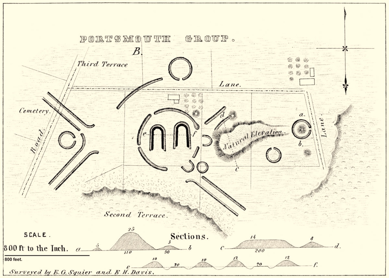
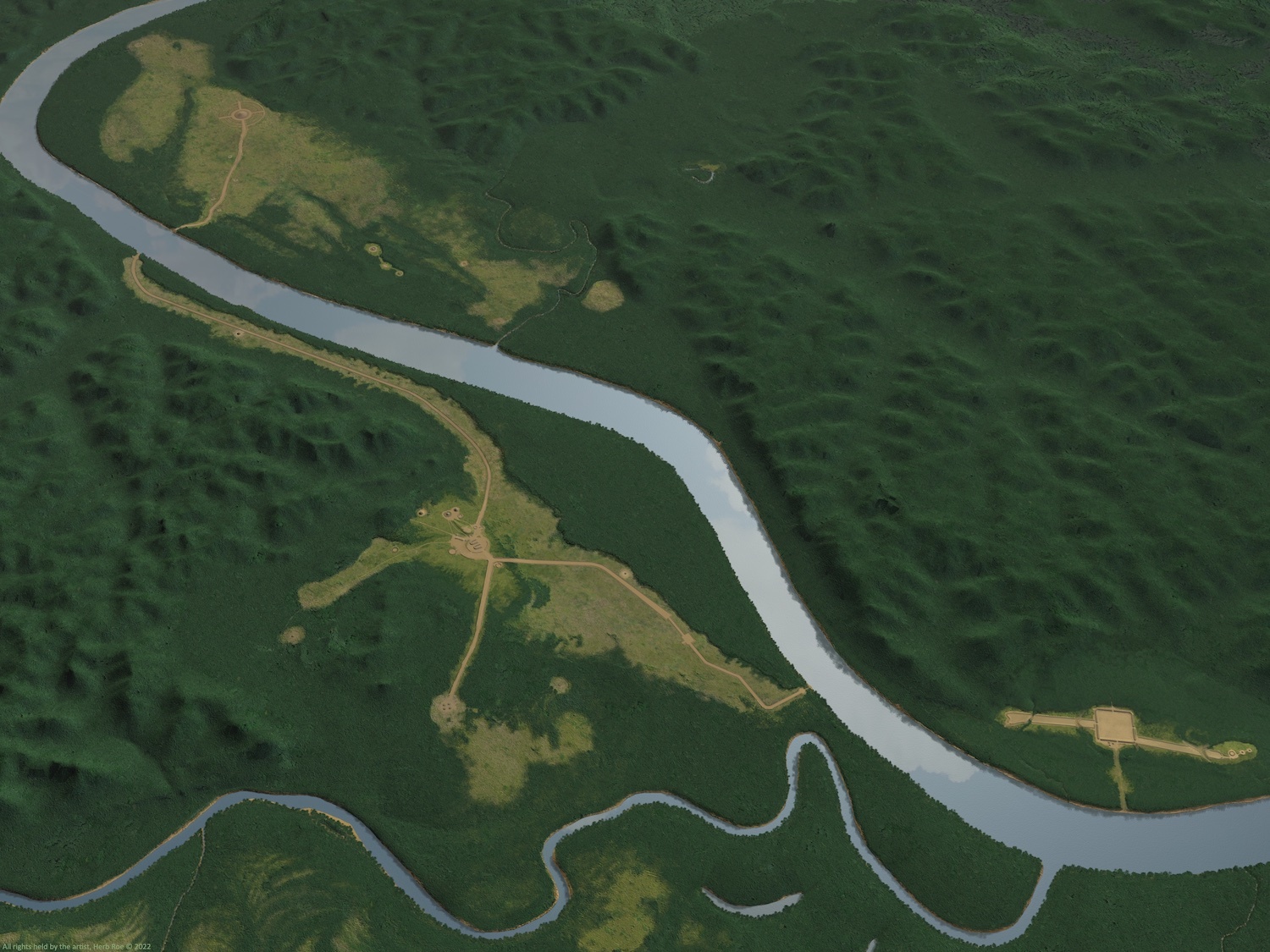
Squier and Davis labeled these as Groups A, B, and C on their map, a naming convention that has been retained by archaeologists to the present. Group A is the rectangular works on the Kentucky side of the river on the first terrace above the floodplain, also known as the “Old Fort” by nineteenth century observers. Group B is the central complex on the high terrace on the Ohio side of the river, surrounding modern Mound Park. Group C is the concentric circle earthworks on the Kentucky side, east of the rectangular works, and on the first terrace over the floodplain (known as the "Temple Mound").
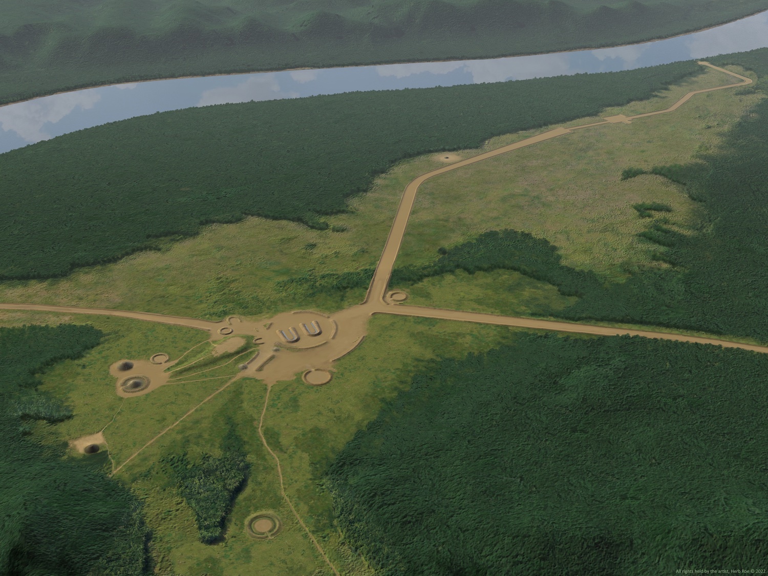
Squier and Davis made special note of a defining feature of this set of earthworks, which were the sets of parallel walls that apparently served to link the three groups. As recorded by Squier and Davis, the main element of Group B was a pair of horseshoe-shaped mounds situated within a semi-circular embankment. The horseshoe mounds opened to the south, and there were wide openings in the semi-circle to the east and southeast, with smaller openings at the west and northwest.
Two smaller U-shaped mounds were situated at the large openings, with their open ends oriented towards the openings of the large horseshoe mounds. A circular embankment was present directly east of the southern U-shaped mound. To the northeast of the eastern U-shaped mound, a short set of parallel embankments led northeast for a brief distance, with a mound at the northeast end of the southern embankment. Another mound was present to the northeast of the eastern horseshoe mound, outside the semi-circular embankment.
Further removed to the north, across a farm lane that is now 17th Street, was a circular embankment with an opening on the south side and centered on the center axis of the eastern horseshoe mound. Southeast of this circle was a long, singular, arcing embankment, leading southwest to the northwest set of parallel walls.
Another circular embankment was present to the west of the junction of the two sets of parallel embankments, with an opening to the east and on a central alignment that passes through the middle of the two horseshoe mounds and the eastern U-shaped mound.
A natural rise on the terrace is east of the horseshoe mounds, with one circular embankment south of the rise and another at the toe of the rise to the east. This second embankment enclosed a central mound and had an opening oriented to the east. Squier and Davis noted they thought the natural rise had been artificially modified, likely for use as an elevated platform overlooking the central earthworks.
The development of Portsmouth throughout the nineteenth and twentieth century removed nearly all visible traces of this complex earthworks. Today, only the horseshoe mound in Mound Park remains of the Portsmouth portion of the earthworks to remind us of this once-massive ritual center.
Adena and Hopewell Construction of the Mounds and Earthworks at the Mouth of the Scioto River
Earthworks served specific functions in Hopewell society, although this is the subject of robust debate amongst archaeologists. Most scholars tend to agree the general function of these constructions served as ritual centers for local, and perhaps regional, Hopewell communities, while there must have been variability in the ways that earthworks and mounds served local and regional communities. Earthwork construction by the Hopewell is linked to the earlier mound and simple geometric earthwork construction practiced by Early Woodland people (1000-100 BC), particularly the Adena cultural groups. Adena mounds range from low rises to large conical mounds highly visible on the landscape, often including multiple burials. Adena earthworks are usually circles with a single opening and an interior ditch, often with a central mound, and are often found in groups.
The archeaological record suggests that the Portsmouth Earthworks originated in the Early Woodland period as such a group of circles and mounds, then was expanded during the Middle Woodland by Hopewell people. The link between Adena and Hopewell cultures is not completely understood but it is probable that the Hopewell culture is an evolution of earlier Adena customs and practices.
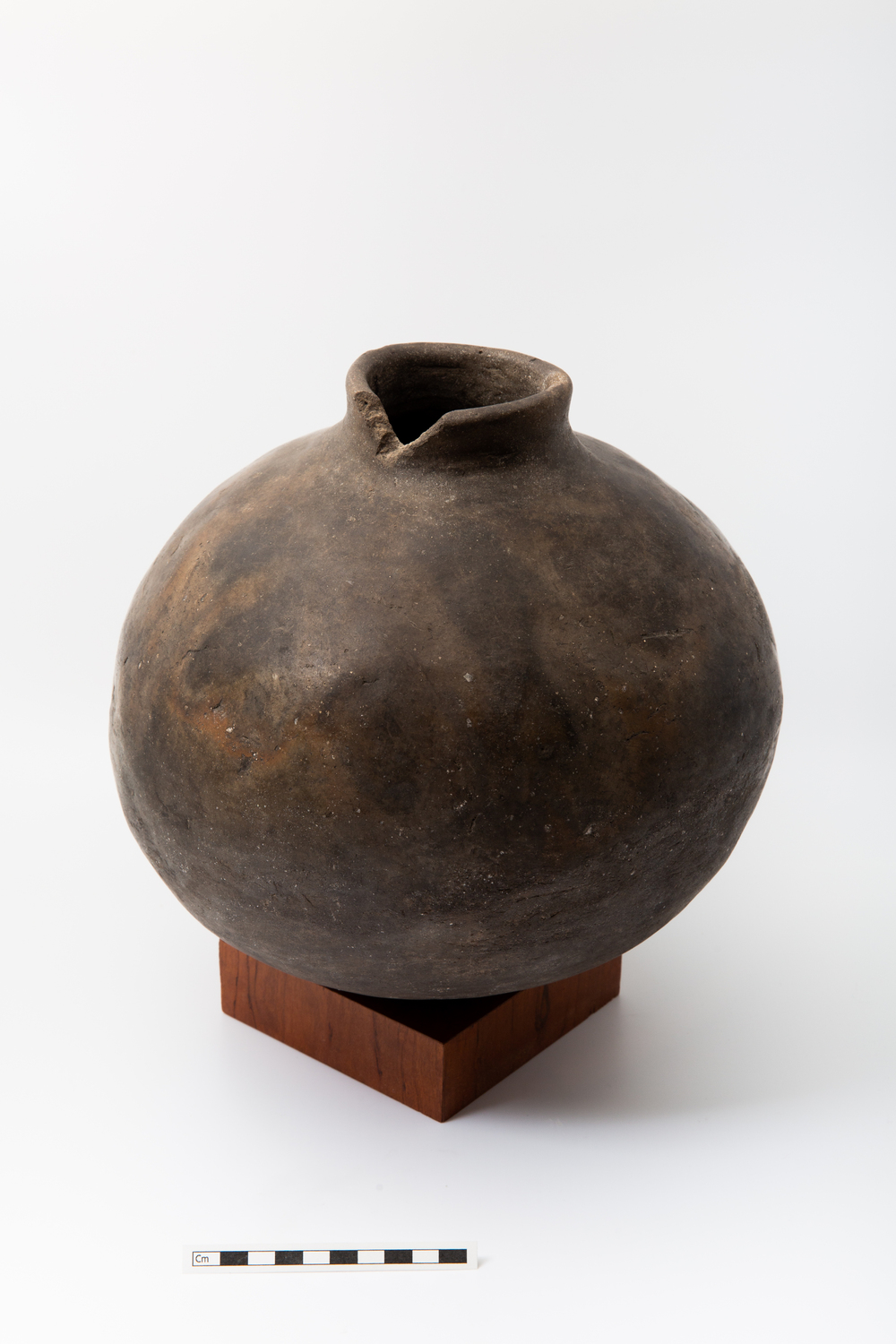
The exact purpose of the Portsmouth Earthworks is unknown, but it is clear they were a major component of the ritual life of the Middle Woodland Hopewell Culture (ca. 100 BC-500 AD). The earthworks are the southernmost earthworks complex along the Scioto River. This complex likely had a special association with the junction of the Scioto River and Ohio River, perhaps serving as a gateway into the heart of the Ohio Hopewell homelands.
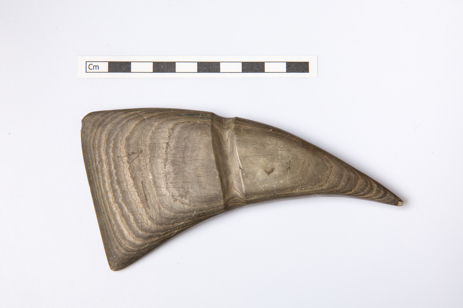
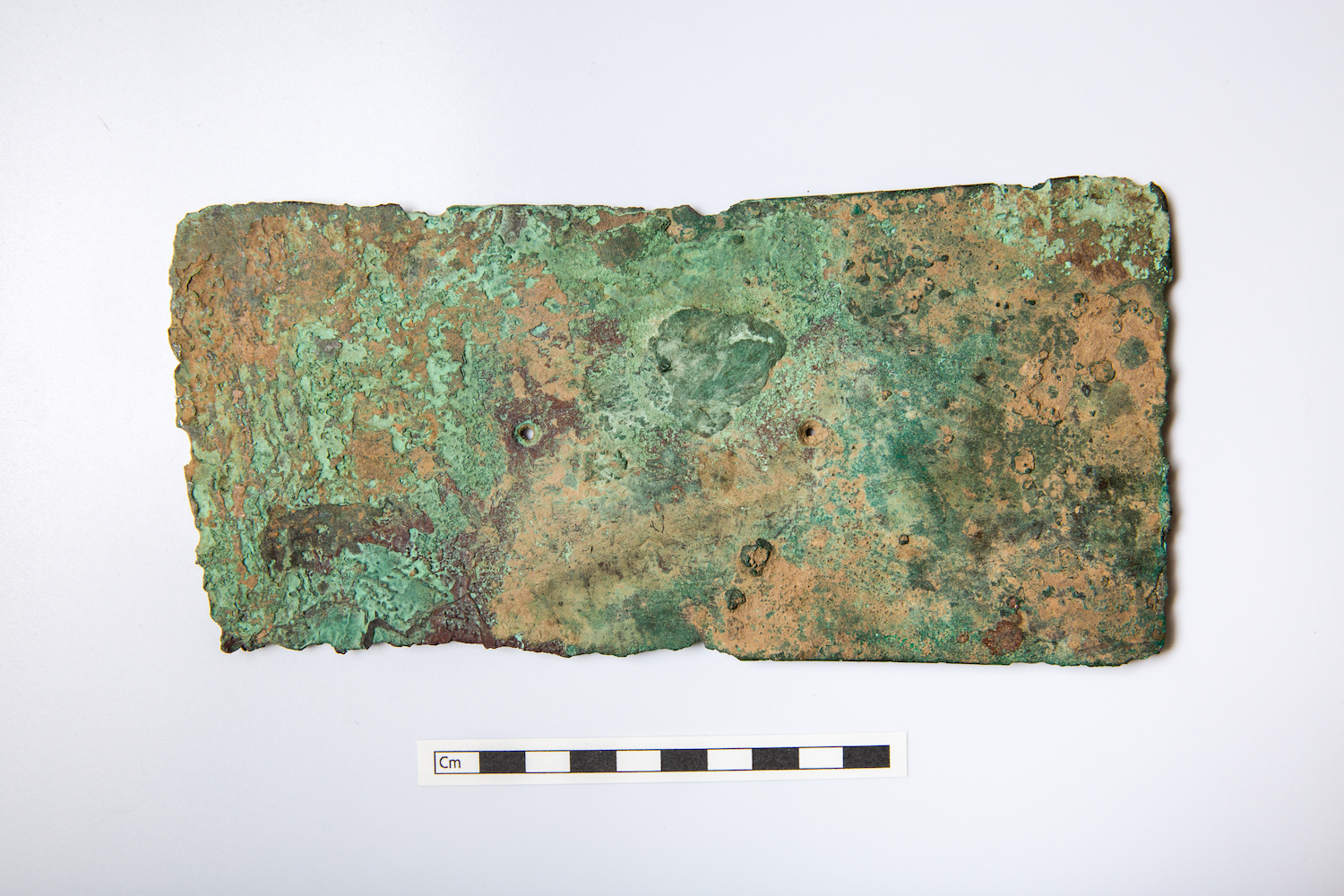
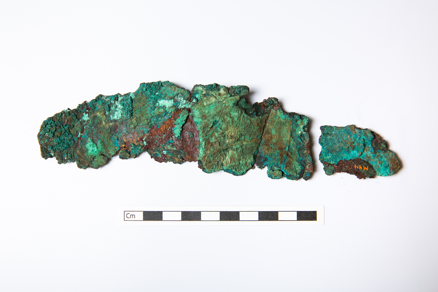
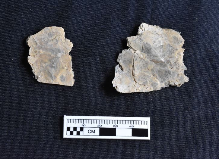
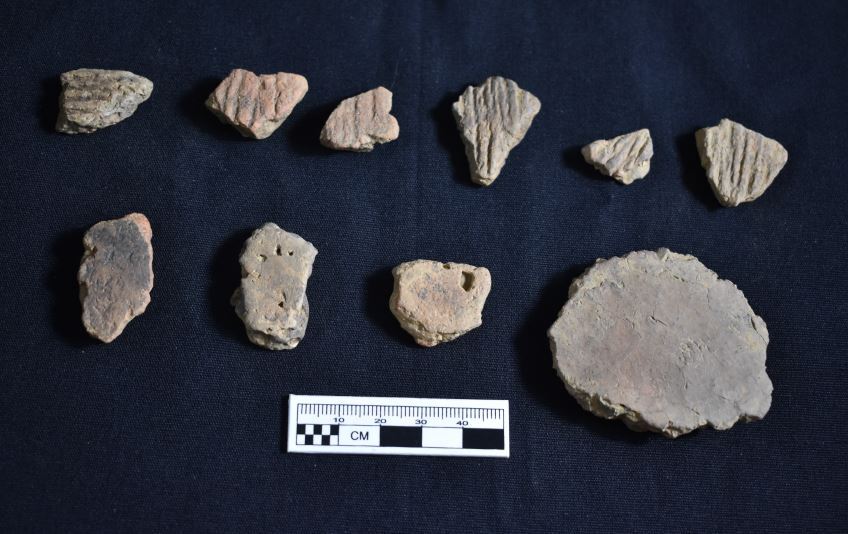
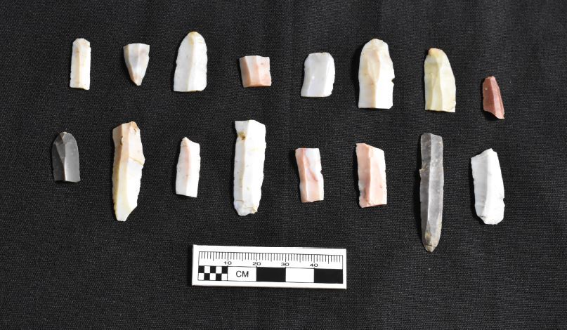
Like other earthworks complexes further up the Scioto River valley, the Portsmouth Earthworks probably served as a gathering place for both local families scattered across the landscape in small hamlets and for larger congregations of people from other river valleys across the region. Recent archaeological excavations at the park have recovered exotic materials from distant locations, including mica and crystal quartz from the North Carolina mountains and obsidian from the Yellowstone region, along with massive quantities of Ohio Flint Ridge chert.
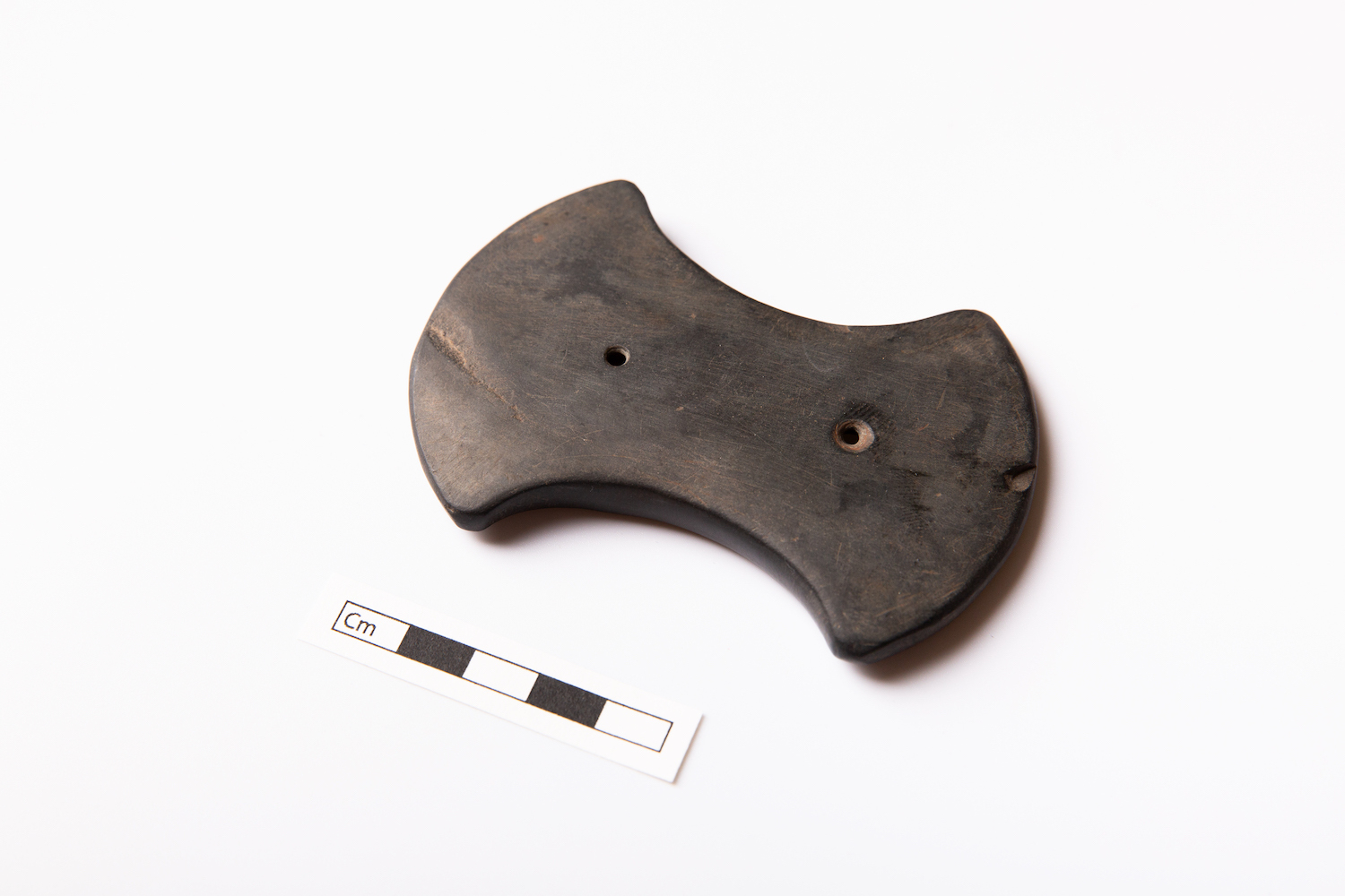
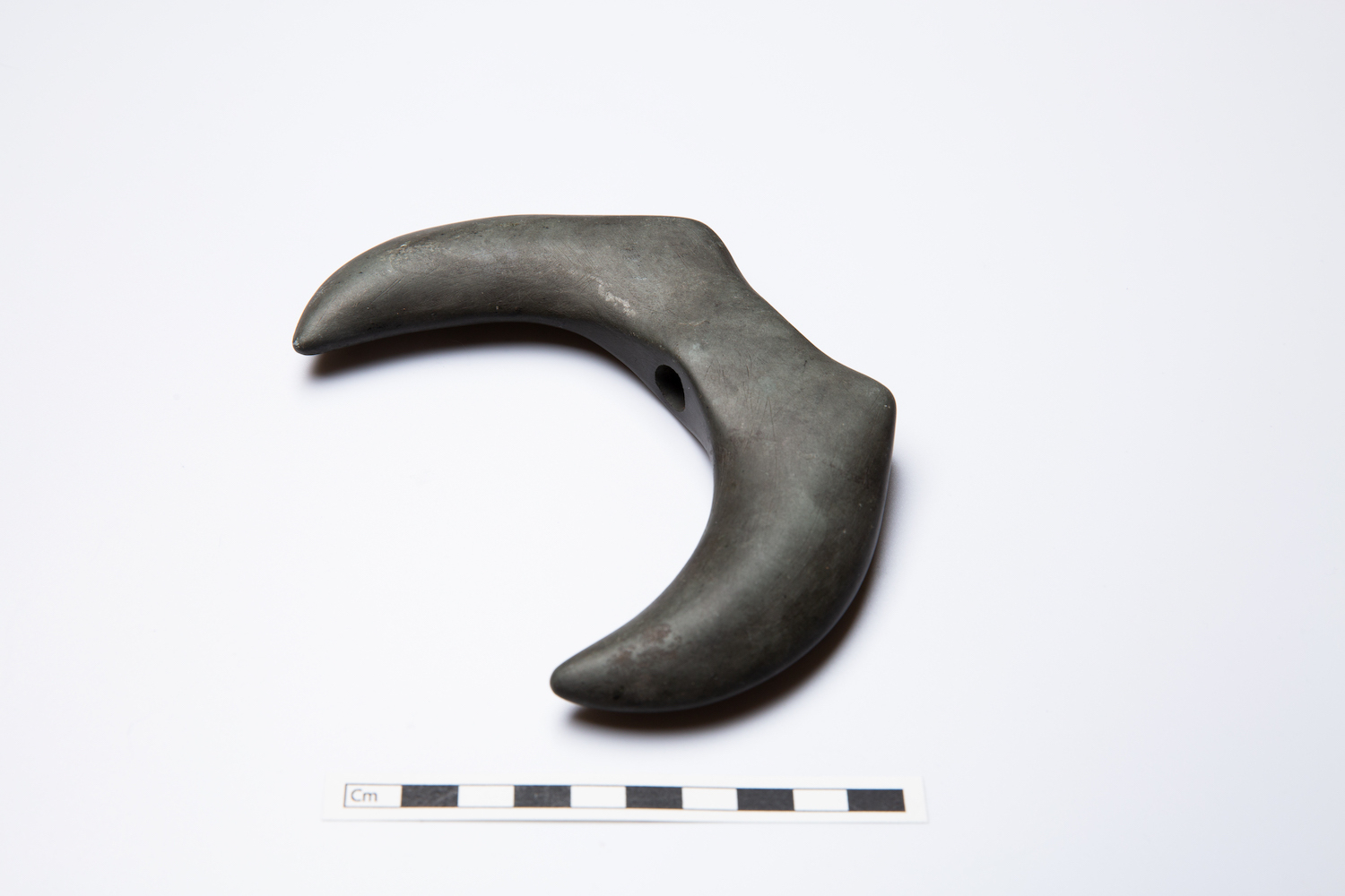
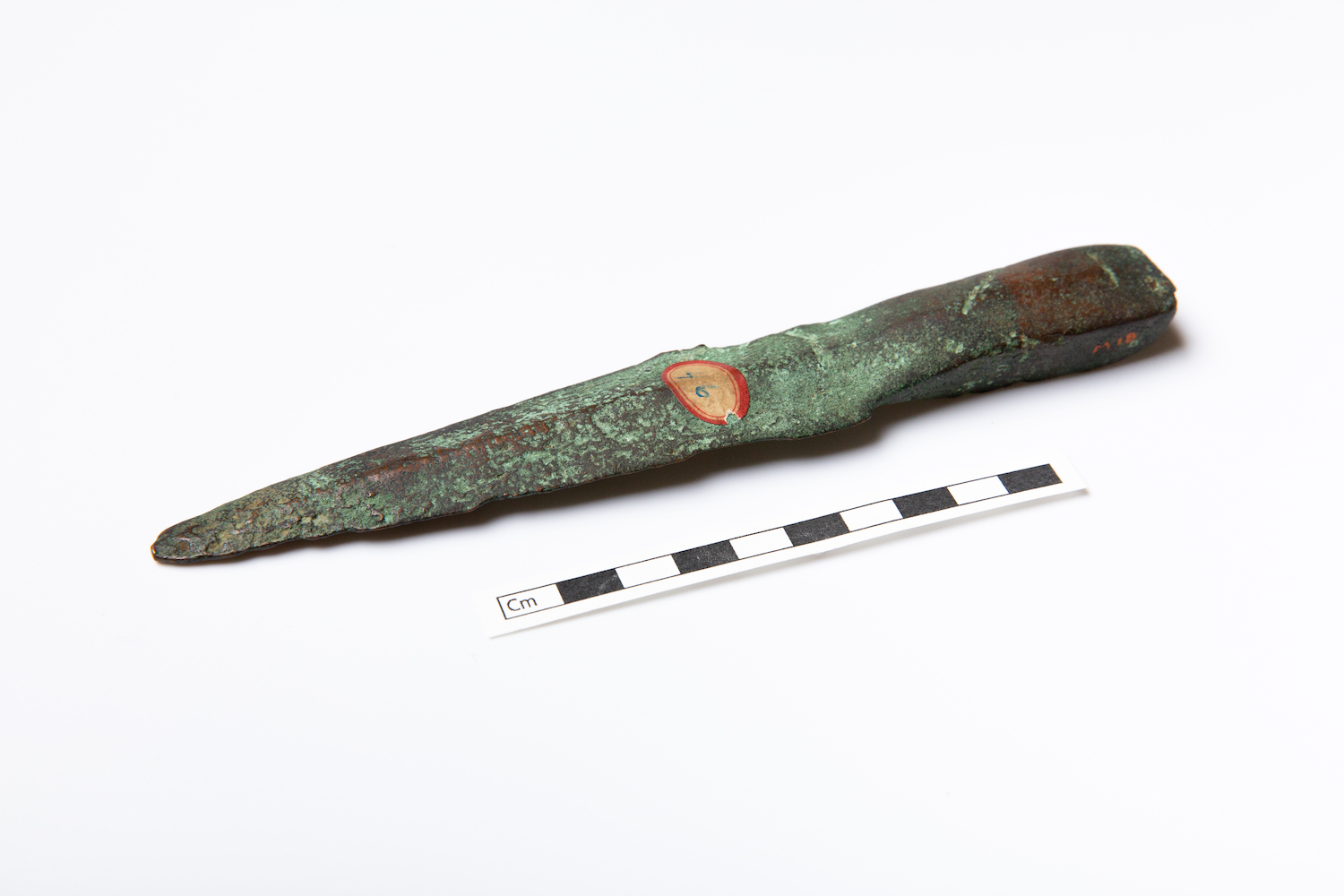
Exotic material brought back from distant lands was used to make iconic works of Hopewell art, such as mica cutouts, huge obsidian blades, conch shell dippers and beads, copper panpipes and body ornaments, and necklaces of grizzly bear and fossil shark teeth. While none of these artifacts are currently known from Mound Park, it is likely that similar artifacts were made and used here.
Early Historical Occupation
Mound Park was originally part of the John Simpson farmstead, established sometime before 1819. John Simpson and his wife Mary Noel were among the first settlers of Portsmouth. They set up their farm just north of the large semi-circular embankments that enclosed the horseshoe mounds. As a carpenter, Simpson likely had a hand in the construction of many early buildings in Portsmouth. Later, in 1846, Azel Glover sold six acres of this parcel to the County Commissioners for use as an "Infirmary Farm."
In the 1860s and 1870s, the County Fair would be held on the site of the farm. In 1871, the Portsmouth Times reported on the preparations for the annual fair, noting that there were “several ancient mounds of peculiar formation” on the grounds. The main exhibition hall was built within the interior of one of the horseshoe mounds, and a racecourse was set up east of the mound, with a music stand on the rise where the WPA-built Shelter House is now located. A Dr. Straight was noted as the owner of the grounds at the time and had his residence there.
In 1871, the County Commissioners transferred the Infirmary Farm to the West Side, near Carey's Run, clearing the way for a new chapter in the site's history.
Scioto County Children’s Home
The Scioto County Children’s Home was the county orphanage. The Portsmouth City Council set aside part of the City Hospital for the home in 1874.
And, in November of 1875, the Portsmouth Times noted that the old fairground buildings were being repaired for temporary use by the county's Children’s Home. The fairgrounds are shown south of Robinson Avenue on the 1889 map of Portsmouth, showing their movement away from Mound Park.
In November 1875, the orphanage was moved to the old infirmary farm and fairgrounds property on the current grounds of Mound Park. The old infirmary and fairground buildings were repaired for temporary use, while plans were launched to construct a new building to serve as Children’s Home.
Built atop the natural rise, overlooking the Horseshoe Mound, the new home burned in early 1876 before it was finished. After rebuilding, a three-story brick structure opened in 1877 in the same location. By 1892, seventy-five children occupied the Home, and the buildings on the grounds included the residence, a one-story schoolhouse, a laundry, a playhouse, two other outbuildings, and a windmill. All these buildings were in the southeast corner of Mound Park, where the 1930s shelter house and equipment shed are now present.
An early, undated nineteenth-century photograph of the home also shows what must be the small U-shaped mound that was on the property. Towards the end of the 1880s, city officials discussed the possibility of constructing an addition to alleviate crowding. By 1909, there was talk of relocating the facility, and with it was the first mention of converting the property to a city park, with the special notation to preserve the earthworks. Other options including selling the whole property for residential lots or building a new city hospital on the site.
Interestingly, a 1915 article discussing the disposition of the Children’s Home mentions “historical horse-shoe mounds” – so it is possible that the smaller U-shaped mound as seen in the undated photograph was still present. In 1917, the county commissioners resolved to divide the Children’s Home property into four lots and sell them to raise funds for a new home located in a more rural setting. However, this plan ran into resistance from residents of the Hilltop neighborhood and community groups who supported transforming the grounds into a public park.
The Labold family eventually purchased the entire plot and transferred the deed to the City of Portsmouth to explicitly transform the grounds into a new city park. Construction on a new Children’s Home near Wheelersburg began in 1920. The Children’s Home remained in this location until 1921, after which the location was converted to a public park, following the desire of many Portsmouth citizens.
The outbuildings of the Children’s Home began to be removed by 1922. For a time, various uses were considered for the residential building, such as conversion into a Community Club House for use by the various community organizations of Portsmouth. The Boy Scouts planned to convert the building to their local headquarters in 1923. In 1928, the Portsmouth Lions Club floated a proposal to demolish the old Children’s Home building and use the materials for a city museum on the same location, but it was razed later that year without any immediate rebuilding on its footprint.
Establishment of Mound Park
The park opened in 1921, serving mainly as an open green space at first. Although a nearby business named itself “Mound Park Pharmacy” the park was generally referred to as the Children’s Home Park in the early 1920s. Early improvements at the park include the construction of shelter houses and equipment sheds. In 1933, a shelter house was built on the old location of the Children’s Home, replaced in 1937 by a WPA-built stone veneer shelter house, and followed in 1938 by a stone workshop building. A stone “tool house” was noted as built near the roque court, itself installed in 1935.
The CCC sent men to assist with flood recovery in 1937 and they camped at Mound Park. In By 1939, a bandstand for concerts was built somewhere on the grounds, possibly within the horseshoe mound. In 1941, a 46-foot-tall flagpole was erected in the park just north of the shelter house.
Public Gatherings at Mound Park
Even when it was still the Children’s Home grounds, the park area was used by local groups for gatherings, such as picnics. In 1920, the Girl Scouts had a May Day festival attended by 150 girls from around Portsmouth. The Boy Scouts followed with their own Scout Show in 1923, which returned in 1924 and 1925 before moving to Labold Field in 1926 to take advantage of better facilities for handling crowds and events. However, the Boy Scouts still used Mound Park for smaller field events.
The Highland School inaugurated an annual Field Day at the park in 1921, with around 2,000 people in attendance. Portsmouth’s Community Chorus held free concerts in the park in the 1920s. The city held its own memorial service in Mound Park for the death of President Harding in 1923. During the warm weather months, many local churches held open-air services and picnics at the park and family reunions were a common occurrence.
In 1928, a band platform was erected in a shady section of the park for concerts; newspaper accounts suggest this platform may have been erected within the horseshoe mound, as concerts were held at the corner of Grant and Hutchins streets. However, a new band shell was proposed in 1942 to be erected between the mound and shelter house, which is another plausible location for the original bandstand.
Not all assemblies were benign. The Ku Klux Klan met for a rally and march through Portsmouth at Mound Park in late 1923; however, they were quickly arrested after refusing an order to disperse.
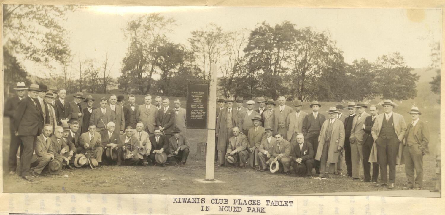
The park is still a focal point of outdoor activities for the surrounding neighborhood. Tennis, softball, and basketball games are played in the warmer months and the play structure is popular with local children. The 1930s shelter house is still used for gatherings and activities. Most recently, a park improvement project completed a paved walking path and the installation of several park lights to improve safety and access for the park. The ancient history of Mound Park is commemorated by a new monument and plaza northwest of the mound along Hutchins Street.
Sources:
Portsmouth Daily Times (1870-1941)
Evans, N. W. 1903 History of Scioto County. Self-published, Portsmouth, Ohio.
Holt, R. B. 1878 The Earthworks at Portsmouth, Ohio, U.S. The Journal of the Anthropological Institute of Great Britain and Ireland 7:132–137.
Inter-State Publishing Company 1884 History of Lower Scioto Valley, Ohio. Inter-State Publishing Company, Chicago.
Portsmouth Public Library 2019b Henry A. Lorberg Telegram, 1928. Local History Digital Collection, https://www.yourppl.org/history/items/show/2093, accessed June 7, 2019.
Squier, E. G., and E. H. Davis 1847 Ancient Monuments of the Mississippi Valley. Smithsonian Institution, Washington, D.C.